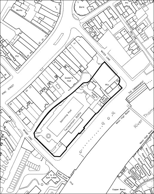
| Figure 1 - The Twickenham Swimming Pool Site |
| (Click on the map to download an enlarged version - 88kB) |
 |
| [Contents Page] |
The Public Asset - analysis of previous proposals
The pool site is situated on the Riverside close to the commercial centre of Twickenham and the Riverside. It can, and should, act as a focal point for the regeneration of both the town centre and the riverside.
| Figure 1 - The Twickenham Swimming Pool Site |
| (Click on the map to download an enlarged version - 88kB) |
|
The site lies within the local riverside community which is bounded by Wharf Lane, the service road behind King Street, Church Street, Church Lane and includes Eel Pie island. The area is a robust socio-economic system with some 400 residents, 40 shops/offices, 9 pubs & restaurants, 30 other small businesses ranging from light engineering to architects and artists, 5 boat yards, a church, an amateur theatre and 2 active sports clubs. The area, population and business units are split almost equally between Eel Pie Island and the mainland. The location is visually attractive with a good blend of historic buildings, ancient lanes and stunning river views. It is unique. It is very different from the beach at Richmond and requires a different approach to its development.
Visitors appreciate and enjoy the activity on the river arising from the activities of the boat yards. Few are aware of the importance of these yards to river boat activity throughout the length of the Thames. As a consequence of piecemeal development of riverside sites, many boat yards which support all of the craft on the river are going out of business. Eel Pie Slipways is one of the last boatyards on the river empowered to provide safety certificates for the big pleasure cruisers on the river.
At this point the Thames is tidal. This means that at low tide, boats regularly go aground, and at high tide the Embankment is flooded. Several times a year, the water covers the lower end of Water and Wharf Lanes and goes over the pavement alongside the pool. For this reason alone, any development on the pool site has different parameters than a development in a non-tidal area.
| Figure 2 - Tidal Flood Levels |
| (Click on the map to download an enlarged version - 64kB) |
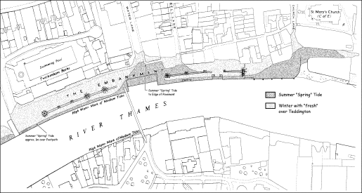 |
By virtue of its proximity to the River, the site is first a riverside site and secondly a town centre site. The ideal to be aimed for is a synergy between town and riverside.
The working group notes the sustained commercial success of the Church Street traders who already attract significant and local trade to the area. There are opportunities to manage a significant increase in the tourists coming to the riverside area of Twickenham and that these will contribute materially to the regeneration of the centre.
The group has:
The principle of these are listed below.
1. To increase tourists and visitors to Twickenham by :
- A landmark design piazza for markets, open-air entertainment, in the Covent Garden style, art displays, etc.
- A central water feature
- An increase in river-based activities attracting participants and viewers
- A Thames River-Life Discovery Centre with interactive displays, linking with working boat yards and the local environment, with a programme that addresses the needs of all sections of the community
- A Tourist Information office which carries displays by local artists and provides space for river-based organisations such as the Thames Landscape Strategy
2. A pontoon or landing stage and new boat services 3. Environmental improvements and a renovated Embankment
All of these things are practical and can be achieved.
Any proposals for the site have to take into account a number of constraints:
1. Physical. It is a relatively small site with limited access, parts of which are subject to frequent flooding. 2. Traffic, access and parking.
- At present there is a one way circulation of traffic from Water Lane across the Embankment to Wharf Lane. There are loading bays on the Embankment to service the businesses, Boat Clubs and residents of Eel Pie Island, whose sole access is via a pedestrian bridge. Some of the loads require considerable space and may be present for several hours, e.g., furniture removal vans, trailers for rowing skiffs. There is insufficient width in Water and Wharf Lanes to make them two-way.
- The Council’s current policy is for no vehicular access to the Embankment.
- The Council is proposing to replace 61 parking places on the Embankment with 31 in the new development, thus reducing the total number of publicly available parking places in the whole of the riverside area from 185 to 154.
- The number of place in the Holly Rd car park is 161. This compares with the 750 places in the Eden Centre and 1185 in the Bentall's Centre in Kingston.
The Inspector’s report from the 1990-91 Public Enquiry stresses the significance of the site as a riverside site and recommends that only 2-3 storey buildings should be allowed. The Unitary Development Plan for the site, which was arrived at after extensive public consultation, states the prime use of the site is to be for leisure.
Whilst taking cognisance of its strategic objectives for the site, the Council is obliged to obtain best value for the site, and it seeks to make the development pay for the public asset component.
The Public Asset – analysis of previous proposals
The work throughout the summer has provided answers to an number of key questions, and guidance on important issues. There is still a level of uncertainty about how large an area of building should go onto the site; however, it appears that the maximum size of development that will be acceptable to the community and comply with the planning guidelines is in the area of 9,000 – 9,500 square metres.
The following table summarises the recent schemes for the pool site, in terms of the amount of commercial building compared to the amount of public asset.
Comparison of development schemes:
Scheme |
Commercial building |
Public building |
Total |
|||
| Area, m² | % | Area, m² | % | Area, m² | Scale £ | |
| Competition (original) | 4,125 | 56 | 3,185 | 44 | 7,310 | |
| Lottery bid | 7,865 | 81 | 1,845 | 19 | 9,710 | |
| January, 1999 | 13,141 | 82 | 2,820 | 18 | 15,961 | 27M |
| April, 1999 | 10,700 | 78 | 3,054 | 22 | 13,754 | |
| October, 1999 | 9,600 | 90 | 1,080 | 10 | 10,692 | |
Building areas are taken from the submissions by Alsop Zogolovitch and First Premise Ltd.
In a separate exercise, Prof Betteridge and architect Robert Bowcock together with Donaldson’s, the Council’s financial advisors, carried out a financial modelling operation using Donaldson’s commercial model. This revealed that a lower cost development was feasible, with 4,400 square metres of commercial building providing sufficient revenue to provide 1,500 square metres of public asset building (equivalent to the Riverside Centre, set out in Section 3 of this report).
The model shows that the large costs associated with the developer’s plans come from the perceived need to dig deep foundations to gravel level, plus underground car parking and facilities (the health club and/or the cinema).
Donaldson’s model also shows that if normal foundations are dug, as in the Water Lane housing development, a large part of the costs are avoided: however, there is no space for underground car parking.
The financial return on buildings is set out in appendix 1.
| [Contents Page] |